|
The Versluice Meadows had been soil mined for 20 yeras beginning in 1985. This lower the meadow by as much as 7 meters in some locations. Porter Creek was re-routed in 1899. A culvert over the creek where it entered the Meadow, caused a substantial overflow problem, Flow into Hidden Lake was cut off and ice formed across the Meadow, Ice went as high as the windows of a house built near the south end of the Meadow. A restoration of the creek was proposed by the PC Community Association.
|
|
As part of the restoration of Porter Creek across Versluice Meadows, it was proposed the creek be re-routed. This required a surveying of the creek in the ditch, measuring the slope of the creek over the course of the proposed restoration, recording seasonal flow rates and mapping the sinuosity of such a creek at the proposed gradient as outlined in a text on low gradient stream restoration. ES students took part in each phase of this project.
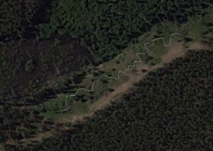
We used standard survey practices to measure gradient. A split bubble level was used to determine the drop in the creek from where in entered and exits the Meadow. We used to 20 cm pixel ortho photos from Whitehorse to record the stream sinuosity in a similar gradient reach upstream from Rabbits Foot Canyon. We confirmed these measurements with tapes and on-sight measurements. We then mapped out a proposed routing for the creek that would stabilize the creek in all seasons.
The PC Community Association discussed plans for the creek and the meadow. Sketch plans that included a small lake with a central island at the northern end of the meadow that could be used for winter skating and summer a waterfowl refuge. In order to create a lake we needed information about the ground water levels. ES students with aid from Tetratec and Y2C2 placed 15 piesometers around the meadow to determine ground water levels. We found that water levels at all seasons were at the surface at the northern side of the meadow and concluded a lake could be developed here. CC Dirt and Gravel offered to create the depression when their soil stripping contract was completed in a year.
Unfortunately, the City of Whitehorse approved a subdivision of the Meadow that subdivision over rode proposals for the stream restoration and the lake development. ES argued that the small lake would act to clean the water before in flowed into Hidden Lake. The pond would act to reduce the nutrient load in the creek by having another water body upstream. The problems persist through to 2015. Hidden lake continues to rise and the algae growth continues during the summers. The water balance has not yet been achieved.
