How Quad Use impacts the Landscape
ATV use in the back country, seen by many as a recreational activity, may leave long term scars and negative impacts on the landscape. The extent to which quad use may disturb ground cover, aquatic systems, and alter soil profiles is a study undertaken by ES students in 2004-5 in the Yukon College non-motorized vehicle endowment lands. The class explores ways in which the impacts could be quantified. We decided to level a section of ATV track on a corner along the Millennium Trail, place pins adjacent to the trail and provide a cross section map of the trail at that point. We then went back to the site on four occasions to measure the differences from the level bench mark to the trail profile at the time.
Results: Our first impact assessment took place 21 days after the section was leveled on June 10. Two distinctive troughs were made in the ground 1.0 to 1.5 meters apart. The soil as cut away 22 cm in both tracks and deposited to a height of 10 and 14 cm on the inside and outside of the corner..
Our second recording took place on September 2 2004. At this time the two distinctive troughs were widened to .8 to 1.5 meters apart. The soil as cut away 25 cm in both tracks and deposited to a height of 13 and 20 cm on the inside and outside of the corner.
Our third recording took place on May 26 2005. At this time the two distinctive troughs were .8 to 1.5 meters apart as before. The soil as cut away 27 cm in both tracks and deposited to a height of 13 and 22 cm on the inside and outside of the corner.
Conclusion: The ES classes concluded that Quads had been using the non-motorized trails on weekends and during night times since non had been seen during all our time in the region. They concluded that quads were responsible for altering the terrain. They also concluded that the signage was ineffective as a means of managing the impacts. We then explored the effectiveness of other control options that had been exercised in the area.
|
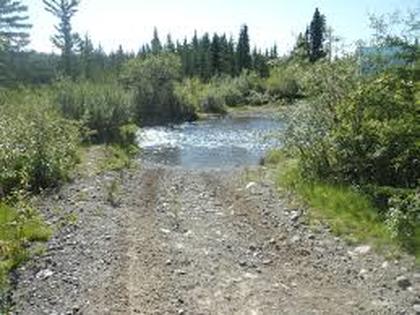
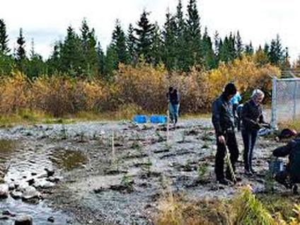
Blocking the trail: At two locations, large boulders were located close together so that quads could not go along the trail. In both cases, quads simply went through the bush and around the obstacles. The only location where this worked was on the lower McIntyre creek bridge where the stream banks were steep cuts and quads could not cross the creek. But at the upper bridge, the creek just downstream was a shallow rocky ford. Obstacles placed in front of the bridge encouraged quad drivers to cross by the ford. This destroyed the bank vegetation and the stream benthoic environment. Attempts to reroute the quads across the bridge by removing the obstacles, by planting riparian vegetation and placing obstacles in from the the ford were unsuccessful for the first two tries. The third re-vegetation effort used logs to support the planted willows appears to have been more successful. All of this occurring in an area categorized as non-motorized. These actions speak to the perception on the part of the quad drivers that the landscape is use as they wish. The ES students recognized that another approach to management and enforcement is required.
|
|
