|
Overview description: Shorekeepers is stewardship of coastal marine habitats by people who live near the ocean. It is a monitoring methodology designed specifically for community groups and for people who may not have a strong science background to be able to contribute to scientific data collection. Having local community groups and individuals take an active role in looking after their coastline fosters “local ownership” and interest.
|
|
Shorekeepers: Intertidal Monitoring Guide was developed by Fisheries and Oceans Canada, to establish a consistent, rigorous intertidal surveying methodology. The method is presented in a logical step-by- step manner starting from selecting a study area through each type of measurement to entering the field data into the database, and finally, reporting your results. The goals of the protocol are to develop long- term intertidal habitat monitoring. Long term monitoring is required to detect gradual changes to habitats and local biodiversity. Shorekeepers is about collecting detailed data annually at the same site(s) for 3 or more years. Shorekeepers is a rigorous monitoring methodology. The key to getting reliable scientific data is to use standard survey methods so that everyone is collecting data in the same way over time at all sites. At least one person on your survey team should complete the Shorekeeper training course. Shorekeepers includes a database application that is user friendly, allowing each survey team to enter their own data and create summary reports of their results.
The Shorekeepers’ Guide includes a training curriculum for Mapping and Surveying Intertidal Habitats. The course teaches participants how to carry out each step of a survey. Training is an important component of Shorekeepers and ensures that data are collected properly. The training is not hard and it is important. Shorekeepers learn an astonishing amount about intertidal life on the beaches near their communities.
By actually having to learn to identify different species of marine invertebrates and algae, one begins to appreciate the beauty and complexity that exists. For example, seaweed may seem like a slippery mass growing over the rocks, but a closer look reveals a myriad of delicate seasonal plants, in colours ranging from pink through green, olive, and brown. Have you ever wondered how barnacles survive out of water for so long at low tide? What creature makes those holes in the sand? Such questions are the same types of questions our school curriculum asks of our students and teachers. Within this context, Shorekeepers is a process many schools should be encouraged to take part in as it addresses curriculum goals while serving larger community and global goals.
The following provides a brief summary of the steps involved in the Shorekeepers protocols.
Mapping and Surveying Intertidal Habitats: This set of protocols describes in a step-by-step manner how to proceed from selection of a survey site through the entire process of mapping and surveying that site. The protoclos involve documenting your concerns about the area and collect relevant maps or charts that encompass the area. Mapping the habitats in your study area and take physical meas- urements of the slope and elevation are outlined in detail. Surveying quadrats within which you will identify and count or estimate each different species of plant and animal is the final step in the field process.
Information Management: These protocols describe the Shorekeepers’ database. It provides a step- by-step guide to using the database, entering different types of data, and producing data summary reports about your survey.
Day of the Survey Activities
Defining Study Area Boundaries and Components Mapping the Study Area
Documenting Physical Features of Each Habitat Documenting Plants and Animals in Each Habitat Surveying the Backshore Zone
Completing the four standardized survey data forms.
Form 1: Study Area Description Form 2: Survey Description Form 3: Habitat Unit Description Form 4: Sketch Map
After the completion of the survey: When all data forms have been completed, the data must be entered into the Shorekeepers’ Database and the data forms must be submitted to DFO. The DFO representative can advise you about entering the data yourself. What follows in this module is the step-by-step procedure for doing a survey and completing the data forms.
Duration of study and numbers involved The intertidal studies have been conducted since 1996 and plots have been set out on SaltSpring Island (4 plots) Prince Rupert (1 plot) Juneau Alaska (1 plot)
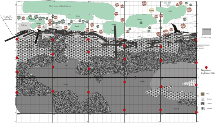
Protocols followed and resources. We found that the naturalists that had followed the shore keepers protocol failed to establish permanent clearly delineated tie points for their studies. We were not confident we were studying the same location. The ES 11 program established permanent monuments, and fixed 100 meter base line and used a theodolite to define the transects perpendicular to the base line. We then mapped the entire intertidal zone and conducted 1 m2 quadrat plots at each .5 meter elevation from 0 tide and mapped all the drift wood at high tide. These results were then digitally mapped with UTM coordinates. The maps were then overlaid the identified areas in Google Earth. These layers, over successive years can be made more or less opaque showing changes in the ecozones from year to year.
Contact person and more detailed information Cate McEwan, Bob Sharp, Kevin O’Connor, Gord Sturrock, Alain Dalaire
The Shorekeepers’ Guide includes a training curriculum for Mapping and Surveying Intertidal Habitats. The course teaches participants how to carry out each step of a survey. Training is an important component of Shorekeepers and ensures that data are collected properly. The training is not hard and it is important. Shorekeepers learn an astonishing amount about intertidal life on the beaches near their communities.
By actually having to learn to identify different species of marine invertebrates and algae, one begins to appreciate the beauty and complexity that exists. For example, seaweed may seem like a slippery mass growing over the rocks, but a closer look reveals a myriad of delicate seasonal plants, in colours ranging from pink through green, olive, and brown. Have you ever wondered how barnacles survive out of water for so long at low tide? What creature makes those holes in the sand? Such questions are the same types of questions our school curriculum asks of our students and teachers. Within this context, Shorekeepers is a process many schools should be encouraged to take part in as it addresses curriculum goals while serving larger community and global goals.
The following provides a brief summary of the steps involved in the Shorekeepers protocols.
Mapping and Surveying Intertidal Habitats: This set of protocols describes in a step-by-step manner how to proceed from selection of a survey site through the entire process of mapping and surveying that site. The protoclos involve documenting your concerns about the area and collect relevant maps or charts that encompass the area. Mapping the habitats in your study area and take physical meas- urements of the slope and elevation are outlined in detail. Surveying quadrats within which you will identify and count or estimate each different species of plant and animal is the final step in the field process.
Information Management: These protocols describe the Shorekeepers’ database. It provides a step- by-step guide to using the database, entering different types of data, and producing data summary reports about your survey.
Day of the Survey Activities
Defining Study Area Boundaries and Components Mapping the Study Area
Documenting Physical Features of Each Habitat Documenting Plants and Animals in Each Habitat Surveying the Backshore Zone
Completing the four standardized survey data forms.
Form 1: Study Area Description Form 2: Survey Description Form 3: Habitat Unit Description Form 4: Sketch Map
After the completion of the survey: When all data forms have been completed, the data must be entered into the Shorekeepers’ Database and the data forms must be submitted to DFO. The DFO representative can advise you about entering the data yourself. What follows in this module is the step-by-step procedure for doing a survey and completing the data forms.
Duration of study and numbers involved The intertidal studies have been conducted since 1996 and plots have been set out on SaltSpring Island (4 plots) Prince Rupert (1 plot) Juneau Alaska (1 plot)
Protocols followed and resources. We found that the naturalists that had followed the shore keepers protocol failed to establish permanent clearly delineated tie points for their studies. We were not confident we were studying the same location. The ES 11 program established permanent monuments, and fixed 100 meter base line and used a theodolite to define the transects perpendicular to the base line. We then mapped the entire intertidal zone and conducted 1 m2 quadrat plots at each .5 meter elevation from 0 tide and mapped all the drift wood at high tide. These results were then digitally mapped with UTM coordinates. The maps were then overlaid the identified areas in Google Earth. These layers, over successive years can be made more or less opaque showing changes in the ecozones from year to year.
Contact person and more detailed information Cate McEwan, Bob Sharp, Kevin O’Connor, Gord Sturrock, Alain Dalaire
