Experiential Science Projects
Projects
Use and Curriculum fits
Aquatic
Study area
Spook Creek
>
Spook Creek, hydrocarbons
Spook Creek: E-coli from Walmart
Spook Creek: Impacts of filling a wetland
Spook Creek: Oil storage and pollution
Spook Creek: Envirothon
Porter Creek
>
Porter Creek, green belt, subdivision,
Porter Creek Water Board Interventions
Porter Creek: Stream shape
Porter Creek: ground water
Hidden Lake
>
Hidden Lake Water Balance
Hidden Lake Algael Bloom
Hidden Lake: Fish Escapes
McIntyre Creek
>
McIntyre Creek: Subdivision proposal
McIntyre Creek: Salmon Spawn
McIntyre Creek: Interpretation trail
Yukon River
>
Yukon River: Rock the River
Yukon River: Structure of standing waves
Ibex River
>
Ibex River: Salmon restortation
Ibex River: Environmental Monitoring
Ibex River: In Stream Incubators
Ford Lake
>
Ford Lake: Water Balance
Ford Lake: Wetland drainage
Ford Lake: Red Winged Balckbird Census
Cowley Lake
>
Cowley Lake: Bathometric Survey
Cowley Lake: Water level, balance
Cowley Lake: Community projects
Cowley Lake: Paleoliminology
Marwell Creek
>
Marwell Creek: Salt Deposited with Winter Snow
Marwell Creek: Hydrocarbons and aquatic quality
Marwell Creek: Escarpment and Hertiage
Takhini River
>
Takhini River: Recreation impacts
Takhini River: Salmon Spawn areas
Estuary studies
>
Ganges Creek Estuary
Campbell River estury health
Terrestrial
Haines Junction Forestry
>
Haines Junction Forestry: Seedling growth
Haines Junction Forestry: Fire regeneration
Haines Junction Forestry: Bais in measurement
Haines Junction Forestry: Blow-down at clearcut margins
Haines Junction Forestry: natural seedlings
Haines Junction Forestry: Spruce beetle infestation
Haines Junction Forestry: infestation in logs
Haines Junction Forestry: Community involvement
Haines Junction Forestry: Spruce beetle trail signage
Haines Junction Forestry: Forest structue analysis
Arctic Institute
>
Arctic Institute: Forest sturcture, hare impacts
Whitehorse Forestry and Terresterial studies
>
Whitehorse Forestry: Fire regeneration
Whitehorse Forestry: Planting seedlings
Whitehorse Forestry: Phenology on Escarpment
Whitehorse Forestry: Plant succession in slides
Whitehorse Forestry: Growth rates
Ground cover studies in Fire Smart areas
Fire scar histories Dendrochronology
Whitehorse Forestry: EMAN plot in regen area
Carbon Sequestering Studies
Teslin Forestry
>
Teslin Forestry: Studies of Different Harvest Practices
Teslin Forestry: Forest volume
Hinton forest structure analysis
>
Hinton forest: Forest regen following burn or clear cut
Hinton forest: Harvest practices near riparian zones
SaltSpring Island forestry
>
SaltSpring Island forestry: sustainable harvesy forest
SaltSpring Island forestry: EMAN Plot in ecological reserve
SaltSpring Island forestry: Deer impacts on forest regeneration
Prince Rupert forestry
>
Prince Rupert forestry Seedling survival in wet soils
Caves
>
Cave mapping
Impacts of clear cutting on caves
Impacts on Land
>
Litter Analysis
Imacts of ATVs on non-motorized trails
Snowmachine trails impacts on plant growth
Wildlife
Mammals
>
Caribou attracted to salt on the road
Caribou and fire smart areas
Caribou use of a potential development area
Hare census by turd counts
Hare impact on seedling survival
Deer impacts on seedling regeneration
Moose brows census
Red Squirrel territories
Mice and genetics
Birds
>
Museum preparation of bird samples
Woodpecker use of beetle killed forest
Sea bird census while sailing
Red-winged Blackbird Census
Bird banding with mist nets
Fish
>
Salmon growth rates and food conversion: Automatic feesders
Salmon fry and complex river systems
Mapping redds on the Ibex
Char escapes on Porter Creek/ Hidden Lake
Trout populations on Long Lake
Insects
>
Aquatic Invertebrate populations analysis
Water quality through aquatic invertebrate populations
Mosquitoe life cycle
Frogs
>
Spotted Frog Census
Wildlife study protocols
>
Motion activated camers
Indirect counts: plants, turds, tracks etc
Frog identification protocols
Radio collar tracking
Mark Recapture protocols
Marine
Intertidal studies
>
Intertidal monitoring through shorekeepers
Intertidal monitoring: Mapping results on Google Earth
Inventory of marine intertidal organizims
Sub tidal studies
>
Fish diversity counts while diving
Anemone census while diving
sea star census while diving
Marine populations
>
Shore crab mark recapture census
Varnish clam census
Barnnacle census on rocky shorelines
Oyster spat growth and setting medimum
Tidal marine aquarium
Ocean Impacts
>
Benthoic samples under booming areas and in open areas
Planton drags and population counts
Shoreline inventories
>
Drift wood seasonal changesd
Plastic in drift wood piles
Fish studies
>
Salmon fry and sea lice
Gee traps for salmon fry
Salmon enhancement processes
Campbell River complex for salmon habitat
Ocean dynamics
>
Character of high energy shorelines
Character of protected shorelines
Long shore drift studies
Atmosphere
Air quality
>
Air quality in Riverdale with inversions
PM 10 meter use
Ozone measurements
Atmospheris dynamics
>
Charting air mass movements from weather data
Recording pressure changes driving from Skagway to Fraser
Measurments
>
Establishing a school weather station
Data logging seasonal temperature records
Snow
Snow Profiles
>
Snow profile measurements: stability
Snow profile measurements: subniven habitats
Snow profile measurements: Hydrology
Snow profile measurements: Seasonal event history
Snow habitat
>
Track records: Caribou activity
Subniven small mammal tracking
Insects in snow
Winter track preservation
Snow characteristics
>
Snow crystal structures
Snow sintering following disturbance: Quinzees
Altering metamorphism in snow profiles
Keeping snow on a skill hill
Snow and climate
>
Temperature varriation across snow and ground
Lake freeze up, break up and ice thickness
Seasonal snow depth and water equivelance measurements
Energy
Energy production
>
Energy production: In-stream generator
Energy production: Datalogger output from a solar pannel
Energy production: Wind generation
Energy conservation
>
Energy conservation: Intelegent parkinglot controlers
Energy conservation: Keeping icecubes insulation
Energy conservation: heat sink measurements
Energy diversion
Recreation
Trail use and development
>
Escarpment trail development
Spruce beetle activity trail
Escarpment trail signage
Development of Yurts near Mystery Lake
Winter activities
>
Ski hill packing
Snowshoeing after caribou
Fitness assessment
>
Fittness Journal with basic standards
Community recreation
>
Trail use records, motion sensors and camera
Environmental Impacts of recational use
Water activities
>
Flow rate measurements
In-stream incubation boxes installed
Gear
Aquatic gear
>
Surber samplers
Stream flow dynamics: flow trough
Flow meters
V notch weir on culvert
Aquatic invertebrate identifcation key
Sucker Uppers
Diatom Identification Key
Plankton Drag
Paleoliminology sampling under ice
Terrestrial Gear
>
Forestry gear
>
Dendrochronology core holders
Go-no go gagues
5 and 10 meter lines
DBH tapes
Collapasable Quadrat plots from tent poles
Clinometers in tangent readings
Soils Gear
Marine gear
>
Seives for fine intertidal substrates
Snow gear
>
Snow profile charts
Snow depth sticks
Snow-water equivelance by weight: total
Snow-water equivelance by weight: layer
Atmosphere gear
>
Rainfall gagues
Wildlife study gear
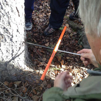
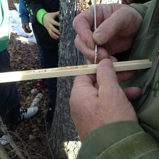
Samples of tree cores provide information about the history of the trees growth. Taking samples with an increment bore does not damage the tree while providing this information. The cores taken with an increment bore